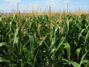
Crop Ratings Slip Nationwide, Improve in Illinois


Published on August 4 2023 8:44 am
Last Updated on August 4 2023 8:45 am
BY DANIEL GRANT FarmWeek
Crop ratings wilted nationwide last week following an extreme heat wave that gripped much of the country.
But, in Illinois, crop ratings actually improved for a fifth consecutive week as the heat dissipated and the storm track remains active.
“Things are much better looking on Aug. 1 than they were July 1,” Trent Ford, state climatologist with the Illinois State Water Survey, told FarmWeek. “But, we do still need rain in August, not only for agriculture, but for hydrology. Stream flows work more slowly than ag.”
Illinois received a preliminary average of 5.08 inches of rain in July, which was 1.02 inches above the 30-year average. This includes massive totals of 6 to 10-plus inches in parts of northeast and southern Illinois, which caused flash flooding in some areas.
That was followed by more rounds of heavy rain, particularly in parts of southern Illinois, the first week of August.
The rain was badly needed as the stretch from April through June was the sixth-driest on record in the state, according to the climatologist.
“Coming into July things were not looking good. It was pretty intense how the drought escalated up to July,” Ford said. “Fortunately for us, what we had is a big ridge parked over the southern and southwest U.S. that cleaned out the northeasterly flow and brought us a more active storm track.
“We ended up with more than 5 inches of rain (for a statewide average) in July. That’s really significant,” he noted. “July was the first month since March that was wetter than normal.”
The portion of crops rated good to excellent improved for a fifth straight week in Illinois to 49% for corn and 46% for soybeans as of July 31. But, despite the recent improvement, that’s still down 25 points for corn and 22 points for beans compared to last year.
Nationwide, the portion of crops rated good to excellent totaled 55% for corn and 52% for beans as of July 31, both down 2 points from the previous week, following the widespread heat wave.
Fortunately, the extreme heat eased in Illinois the first week of August after heat index values reached 110 to 120 degrees for three days.
“Overall, it doesn’t look like the pattern supports anything too extreme (temperature-wise),” John Baranick, DTN ag meteorologist, told the RFD Radio Network. “Hopefully we don’t see anything like that again.”
In fact, the temperature in Illinois last month averaged 75.3 degrees, which was near normal.
“It would’ve been a cooler-than-normal month if not for the last week,” Ford said of the rollercoaster temperatures in July. “That’s been the pattern this summer. It’s not been excessively hot the last 90 days except those last few days in July.”
And the outlook for the rest of August, and final third of the climatological summer in Illinois, looks to be more of a repeat of July rather than a return to the brutal dryness of June with a slight chance of above-normal precipitation and near-normal temperatures.
“The good news for August is near normal, if not cooler than normal, and wetter than normal conditions are expected,” Ford said. “That would make for a really good end to what’s been a very odd and wild kind of (summer) season.”
A downside of the active weather pattern remains widespread reports of severe weather. As of July 31, Illinois already recorded 125 tornadoes for 2023, according to the Storm Prediction Center, and widespread reports of wind and hail damage along with a devastating derecho.
This preliminary total for the year already ranks as the third-highest amount of twisters on record with five months remaining in 2023. The current annual tornado record for Illinois is 142 in 2006.
Illinois typically experiences 50 to 60 tornadoes per year, Ford added.


Community Calendar
- May 1, 2024
Ballard Nature Center Events - May 1, 2024
Grant Applications Open for United Way - May 1, 2024
Library Events - May 1, 2024
National Day of Prayer Breakfast - May 1, 2024
Read, Renew, Repeat - Summer Reading Challenge