

UPDATE: Winter Storm Warning Tonight, Saturday


Published on January 11 2019 7:57 am
Last Updated on January 12 2019 7:55 am
Written by Greg Sapp
Area cancellations, including sports schedule changes are located here
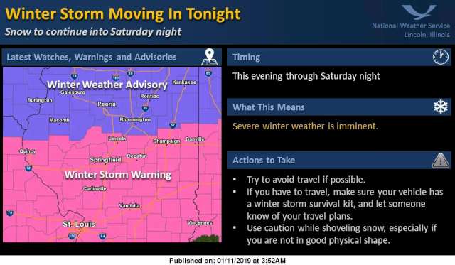
A winter storm system will track across the southern plains today.
As the system moves east toward the southeastern US snow will spread into central Illinois tonight and continue through the day Saturday. Some of the snow will become mixed with rain on Saturday, mainly in areas along and south of I-70.
Total snowfall of 7-9 inches is expected to occur along and south of a Rushville to Lincoln to Danville line, with 5 to 7 inches of snowfall expected north of this line.
Most of the snow will occur between 6 pm tonight and 6 pm Saturday, when 5 to 8 inches is expected. The highest amounts of snow will occur over southwest Illinois where totals could reach 8 to 9 inches.
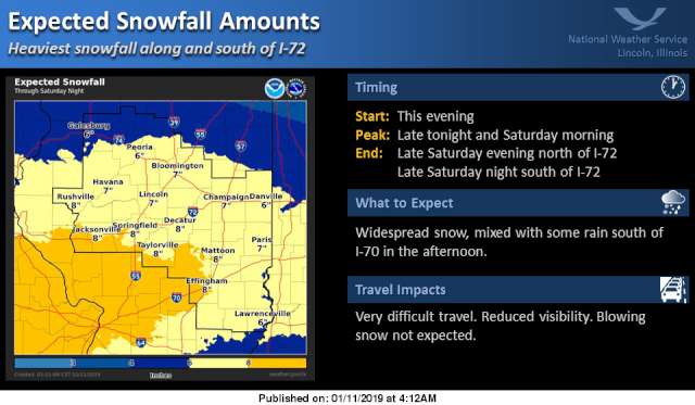
The National Weather Service during a mid-morning conference call indicated 3 to 5 inches of snow could fall tonight, and another 3 to 5 inches on Saturday.
State and local emergency officials urge the public to take time now to prepare your family, home and vehicle. Preparedness tips include:
--Familiarize yourself with the various weather alert definitions, so you know how to keep your family safe
--Winterize your home and take steps to prevent frozen water pipes
--Make an emergency plan for you and your family
--Build a home emergency kit with items such as food, water, medications, NOAA weather radio, flashlight and spare batteries
--Stock your vehicle with the emergency items such as phone charger, blankets, extra clothes, jumper cables, kitty litter or sand, a flashlight and snow scraper in the event you must travel
--If you lose power, seek out a warming center in your area until the power can be restored.
More tips are available online at www.Ready.Illinois.gov.


Community Calendar
- February 11, 2025
Ballard Nature Center Events - February 11, 2025
Catholic Charities Tax Prep Assistance - February 11, 2025
ImpactLife Blood Drive at St. Anthony's Memorial Hospital - February 11, 2025
Library Events - February 11, 2025
Pere Marquette Bald Eagle Days